BUILT ENVIRONMENT AND DESIGN
Type of resources
Keywords
Publication year
Topics
-
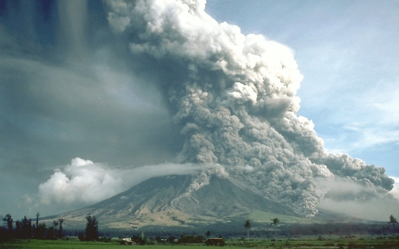
Activity for secondary and senior secondary students examining a hypothetical city and its vulnerability to volcanic hazard risk. Includes background information for teachers, PowerPoint presentation, student activity sheet and worked answers.
-
Knowledge of the nature of buildings within CBD areas is fundamental to a broad range of decision making processes, including planning, emergency management and the mitigation of the impact of natural hazards. To support these activities, Geoscience Australia has developed a building information system called the National Exposure Information System (NEXIS) which provides information on buildings across Australia. Most of the building level information in NEXIS is statistically derived, but efforts are being made to include more detailed information on the nature of individual buildings, particularly in CBD areas. This is being achieved in Brisbane through field survey work.
-
Millions of data points have been acquired or compiled through both phases of the Exploring for the Future (EFTF) program at Geoscience Australia (GA). This data that graces the EFTF Portal and appears in many publications has another home within specialist databases designed and built to house the specific data that GA collects. One such database is HYDROCHEM, which was implemented as part of the Enhanced Data Delivery (EDD) and National Groundwater Systems (NGS) projects. HYDROCHEM hosts 190,097 rows of groundwater, surface water and rainfall water chemistry analyses. This data was either previously hosted in the GNDWATER database, or compiled from legacy data stores. The redevelopment of GNDWATER to HYDROCHEM saw the de-duplication and updating of sample and site-specific metadata into other GA databases, such as SAMPLES, BOREHOLES and FIELDSITES. The redevelopment also added additional constraints to the database, including minimum metadata requirements, constrained look-up tables for units of measure, laboratory, method, filter sizes, standards and uncertainty types. Other features include minimum and maximum values for particular analytes and delivery of the data in standardised GA-preferred units of measure.
-
<p><b>Please Note: Restricted - cannot be made public as it contains sensitive information</b> <p>Record of GA exposure survey in the town of York, WA
-
Knowledge of the nature of buildings within business precincts is fundamental to a broad range of decision making processes, including planning, emergency management and the mitigation of the impact of natural hazards. To support these activities, Geoscience Australia has developed a building information system called the National Exposure Information System (NEXIS) which provides information on buildings across Australia. Most of the building level information in NEXIS is statistically derived, but efforts are being made to include more detailed information on the nature of individual buildings, particularly in business districts. This is being achieved in Sydney through field survey work.
-
Knowledge of the nature of buildings within business precincts is fundamental to a broad range of decision making processes, including planning, emergency management and the mitigation of the impact of natural hazards. To support these activities, Geoscience Australia has developed a building information system called the National Exposure Information System (NEXIS) which provides information on buildings across Australia. Most of the building level information in NEXIS is statistically derived, but efforts are being made to include more detailed information on the nature of individual buildings, particularly in business districts. This is being achieved in Southbank through field survey work.
-
Many scientific talks by Geoscience Australia staff are published on YouTube. These documents provide summaries (‘crib sheets’) of the presentations along with easy access links to each part of the video. They are intended to help teachers of Year 11/12 classes learning about natural hazards
-
The Land Air Marine Access team have developed a Best Practice Standards approach to land, air and marine access and stakeholder engagement to protect Geoscience Australia's social licence and maximise the benefits of our science outcomes.
-
This brochure describes the work undertaken at Geoscience Australia (GA) to develop a blast loss estimation capability for the Australian Reinsurance Pool Corporation. This brochure was developed to accompany a GA record on the same subject. (<a href="http://dx.doi.org/10.11636/Record.2016.022">eCat #101902</a>) Geoscience Australia has developed a modelling capability to estimate the potential impact of terrorist blasts in Australian central business districts (CBDs). With this information, the Australian Government is now able to more reliably estimate insured loss on behalf of the Australian Reinsurance Pool Corporation (APRC). Insured loss is determined based on impact to buildings, contents and business interruption. This capability can now provide blast loss estimates to ARPC in a single business day for the Sydney, Melbourne, Adelaide and Brisbane CBDs. This capability is still in development for the Perth CBD and is expected to be operational by the end of 2016. This blast modelling capability allows ARPC to understand their financial exposure to a range of blast scenarios and assists them to ensure appropriate levels of reinsurance are held to respond to a terrorist incident. Should a terrorist incident occur, loss estimates can be continually reassessed as intelligence from the field is incorporated. Furthermore, the capability provides the ability to assess expected losses across CBDs through simulating many blast locations.
-
Knowledge of the nature of buildings within CBD areas is fundamental to a broad range of decision making processes, including planning, emergency management and the mitigation of the impact of natural hazards. To support these activities, Geoscience Australia has developed a building information system called the National Exposure Information System (NEXIS) which provides information on buildings across Australia. Most of the building level information in NEXIS is statistically derived, but efforts are being made to include more detailed information on the nature of individual buildings, particularly in CBD areas. This is being achieved in the Gold Coast through field survey work.